
"again resumed our journey [ ] got to the Sweetwater about noon [ ] distance 7 1/2 miles [ ] baited our teams and then pased on pased Independence Rock and then crossed the Sweetwater and followed up the south side of the river and camped near Davil's Gap [ ] so cold being a casm in the mountain of about 200 feet of perpendicular rocks [ ] I climbed over the mountain and found several basins of water on top [ ] I drank out of one and found the water cool and pleasant [ ] distance traveled 15 1/4 miles"
********************
I have to smile at some of these entries. In comparison to other journals on the trail, his writing and his spelling are pretty darn good. In this entry he couldn't spell 'past' (pased) and 'passed' (pased) and chasm (casm), but he hit 'perpendicular' on the mark. Charles had a college education, and it shows up in most of these entries.
Very interesting information today on Pioneer Heritage Gateway. I thought it was interesting about finding Soda Springs and finding what they thought might be today's baking soda or "leavening salt" as they called it.

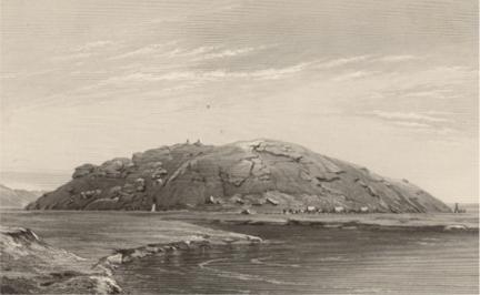
Independence Rock intrigued them. They found many names here already carved into the rock...evidence that they were not the first to roll through here. William Clayton climbed the rock and found that getting down the sloping surface was more difficult than climbing up. The descent was "hard and slipery with nothing to hang on to." Most of them climbed it and took in the view. Here you can see from the top and the Sweetwater River that runs next to it.

Another interesting site they come to is Devil's Gate...another landmark that they knew to look for before they left Winter Quarters. The Sweetwater River runs between the cliffs with the bottom narrowing to the river below. They camped near this site for the night, and many walked back to get a better view... including Charles.
Norton Jacob gives a good account of the day's findings:
"Monday 21st [ ] A Beautiful clear morning moved on S West 7½ miles & halted on the N bank of the Sweet-Water one of the principal Sources of the Platte [ ] this is a Beautiful Rivulet of clear water 50 yards wide [ ] I visited the Soda Spring while we were halted here a mile & a half below [ ] this Spring or more properly a Pool is a great natural curiosity [ ] some 4 or 5 hundred yards in circumference,clear water without anny outlet & having the taste of Strong Lye with a tincture of common Salt [ ] as the water is diminished by evaporation the sand on the shore is coverd with a substance white as the driven Snow & that answers every purpose of Saleratus [ ] I found it lying from ½ to 3 inches thick & soon gathered up a Bucket full [ ] when I returned our camp had started 1¼ miles came to the Southern Point of Independence Rock on the bank of the Stream [ ] this is a Pile of Granite standing in an Isolated position on a level grassy Plain & is 45 yards high & 600 by 300 yards in extent & with a round cap like summit on which there is Pools of water from five to ten feet in width several feet deep [ ] high rocky ranges of Mountains on both sides of the Stream from ½ to a mile distant [ ] in fact a Fortress on this Rock or on another Irregular cragged one five miles above would command the entrance into the Great South Pass of the Rocky Mountains [ ] at the last mentioned place there is a Chasm or rent in the Mountain some 80 feet wide & three hundred feet high through which the River rushes with great impetuosity for 20, 30 rods into the plain below [ ] this Spur of the Mountain has evidently been subjected to Volcanic action [ ] afternoon made 7¾ miles & camped on the bank of the River Just above the Chasm on the South side having forded the Stream a mile above the Independence Rock [ ] two Antelopes were killed today [ ] The Mountain South has snow near its summit"
Check out these videos and website with information about the Sweetwater River, Independence Rock and Devil's Gate. Very interesting.
Below is the top of Independence Rock which they all climbed up and 'claimed'. You can see how the Sweetwater runs next to this interesting part of the trek.
The 'perpendicular rocks' he's talking about is Rocky Ridge. He estimates it as about 200 feet when in reality, he is way off. It actually ascends 700 feet for about two miles making walking, wagons, and animals have a very difficult time going over it. It was east of Rocky Ridge coming up in 1856 when the Willie Handcart Company will be stopped by an October early hard blizzard and will have to wait it out for rescue that they were not even sure was coming.
